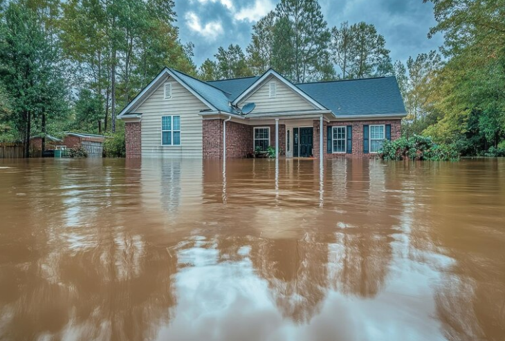
Flood Prone Properties In Houston
FEMA Flood Zone Classifications
A floodplain is typically a flat or low-lying area near rivers, bayous, or coastlines that is prone to flooding when water levels rise. Properties in AE zones are usually located near rivers, bayous, or other water sources and are in the 100-year floodplain with a 1% annual chance of flooding. Shaded Zone X areas, or the 500-year floodplain, have a 0.2% annual chance of flooding, which could occur if Harris County gets about 25 inches of rain in 24 hours.
Most Vulnerable Neighborhoods
Common flood-prone areas include Downtown Houston, where the network of bayous, like Buffalo Bayou, can overflow during major rain events. Meyerland in southwest Houston has been one of the hardest hit in past flooding events, particularly during Hurricane Harvey. Greenspoint in north Houston has experienced severe flooding around Greens Bayou. Kingwood and Humble, located near the San Jacinto River and Lake Houston, have been affected by river flooding in the past.
Extensive New Development in Risk Areas
In the past eight years, builders have developed more than 65,000 new residential, commercial, and industrial properties inside flood zones across Greater Houston's five largest counties. That includes over 57,000 residential properties, or about one in every five homes built during that period. On the Katy Prairie, major neighborhoods like Cinco Ranch, Kelliwood, and Grand Lakes started going up in the 1990s and 2000s inside federally designated flood pools.
FEMA Map Limitations
A 2018 analysis by Harris County found three-quarters of local homes that flooded during Hurricane Harvey were outside the 100-year floodplain. FEMA's flood maps often fail to account for entire neighborhoods vulnerable to flooding. Federal Emergency Management Agency lines are vital for permits and insurance, but they don't always capture rainfall flooding, which can overwhelm streets and storm drains far from bayous.
Geographic and Environmental Factors
Houston's unique in that its flat terrain, large amounts of impervious cover (concrete), slowly-absorbing soil, and potential for thunderstorms, tropical storms, and hurricanes all combine to form ideal conditions for flooding. Houston floods for a few reasons. The most unexpected reason? The city was designed to flood. The majority of Houston's streets are designed to fill with water every time there is heavy rainfall to keep water from entering homes.
High-Risk Property Characteristics
Researchers found big differences where FEMA maps go quiet: older and lower-quality buildings, lower insurance coverage, and a higher share of Black and Hispanic neighborhoods. That combination means greater exposure and tougher recoveries when slow-moving storms park over Houston. Properties near the city's 22 interconnected bayous face the highest risk during major weather events.
Conclusion
Flood-prone properties in Houston include those near bayous, in low-lying areas, and, surprisingly, many outside official FEMA flood zones. During the three-year span from 2015 to 2017, Houston experienced three 500-year floods, including Hurricane Harvey, demonstrating that even properties in "low-risk" zones can flood. Buyers should research multiple flood risk sources beyond FEMA maps when evaluating Houston properties.